
Possibly the most photographed boat shed in the world. But, still, it had to be done.
That boat shed
6

Possibly the most photographed boat shed in the world. But, still, it had to be done.

50, f/11, 1.3″, 20 mm
Circ. polariser, .6 ND hard grad. and .9 pro glass (I think!)
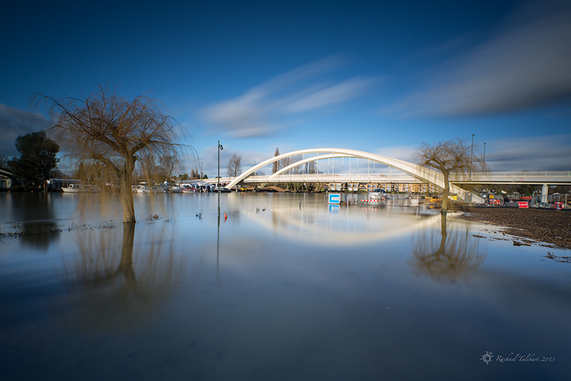
Another shot from Tuesday’s day out along the Wey Navigation. Was it worth it, capturing this towering weather front, in return for three days of foul weather and counting? Definitely.
A return to bugs tomorrow – this warning is for you, Gunta. 😉

The last couple of days have been really foul here – loads more rain that our already saturated landscape really didn’t need, and unremitting grey skies. But on Tuesday, as the weather front rolled slowly in over the Surrey countryside, Jen and I were treated to some seriously epic skies.
Fortuitously, we had chosen for our weekly photoshoot the Wey Navigation towpath between Cartbridge and Triggs Lock. The Navigation is bounded here by water meadows, open spaces and big skies. We were like the proverbial children in the sweet shop (kids in a candy store in American!). It will take me a while to get through all the images I made but here are the first few out of the digital darkroom. Little editing required thanks to my circ. polariser and ND grad. filters. Colours as they appeared on the day.

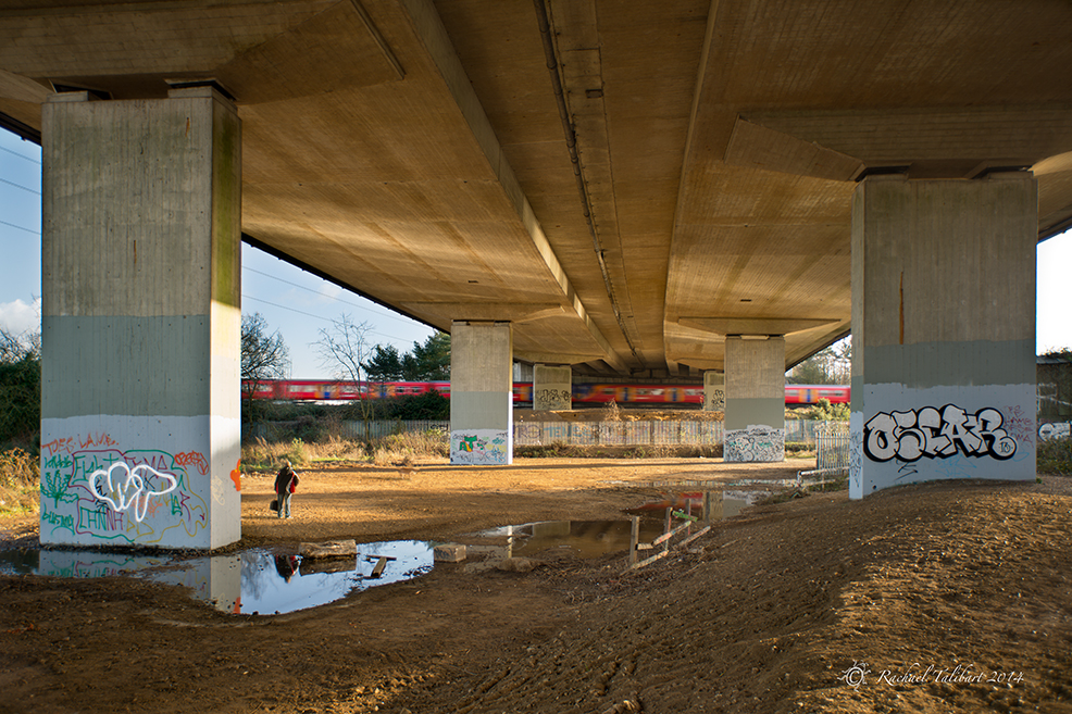
Recently I have started to retrace my steps along the Wey Navigation towpath with a view to getting some more up to date pictures for a possible book project. Most of the Navigation runs through pretty countryside but there is one spot, between New Haw and Pyrford, where it runs close to, and is indeed crossed by, the M25, Britain’s busiest motorway. It is not the most picturesque of landscapes but still full of interest for the photographer. I enjoy the challenge of trying to make images here.

Although not conventionally beautiful, this is a very significant spot in the history of transport. Here, within a few paces of its passage under the motorway, the Wey Navigation meets the Basingstoke Canal. The Navigation is not a canal strictly speaking but a river made navigable, and it predates the canal age by some hundred years. Thus the Basingstoke Canal (opened in 1793) represents a later evolution of British transport, although it was never as successful as the Navigation and fell into disuse first. A sign here points to Thames Lock (3 miles), Guildford and Godalming (12 miles) and Greywell Tunnel (31 miles via the Basingstoke Canal).

Immediately after its junction with the canal, the Navigation passes under a bridge that carries the main London to Southampton railway line (1838). The railways of course were a further development and largely responsible for supplanting the canals as the principal means of goods transport.


Then there’s the motorway, the next stage in the development of transport. An iron footbridge next to the railway bridge adds a further layer, albeit rather older and more environmentally sound!

I have had a few funny looks from people during my visits here, and on a couple of occasions people have stopped to ask me what on earth I am photographing. Yet, rather amusingly, I am clearly not the first photog to see potential in this location, although I don’t think I would ever go to such lengths to advertise my Flickr photo stream!
Some people will do anything to get people to look at their photos
In some of my shots I have tried for a desaturated, moody look, to suit the industrial feel of the place.

But sometimes I just can’t resist going for colour. When the late afternoon sun peeps under the motorway, it almost looks pretty.

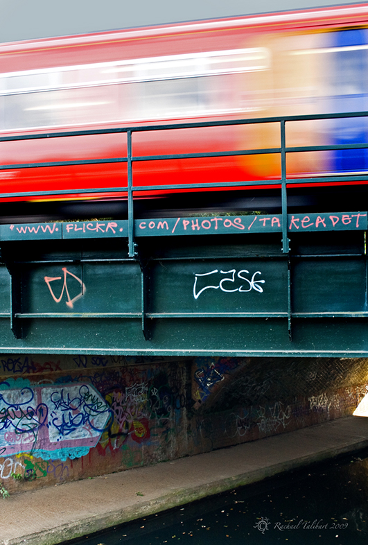
The next shot does not properly belong here as I took it at Weybridge Station, while waiting to meet my daughter. But it was taken on the same afternoon as some of the earlier pictures, just a few minutes later, and it has got a train in it…

Of all the photographs I have taken here so far, strangely my favourite has no train. I like the simplicity of the brick bridge against the sky. It seemed to demand a contrasty black and white conversion.

ISO 50, 16mm, f/16, 11″
ND .6 Hard Grad, Circ. Polariser, .9 Pro-glass

A shot from Tuesday’s visit to Painshill Park in Cobham, Surrey. Those eighteenth century landscape designers knew a thing or two! Two of Painshill’s famous follies are visible in this view, the Gothic Temple and the Chinese Bridge. For the techies, I used a .6 ND hard grad for this shot, and a circular polariser, of course. I have written several other posts about this favourite location of mine. Just click on the tags, Painshill or Painshill Park to find them.

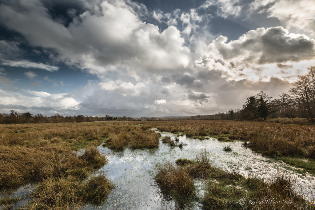
Although the Thames has subsided quite a lot since the worst of the floods earlier this month, it is going to take some time for the waterlogged soil to dry out. This was the scene at the local rugby and cricket club this morning.

The standing water makes for some pretty reflections, but not much good for playing!

Still, there is improvement; I couldn’t have stood in this spot last week.

Last Tuesday

This long-exposure malarky is a lot of fun.
Believe it or not, I now Tweet. (I can’t believe I am saying that!) Find me @RTalibart.

ISO 50, f/16, 8 secs, 16mm.

Last month, I posted some images of our local starling murmuration. I popped back three times last week and was delighted to find them still there, doing their thing, only in greater numbers. Yesterday was the best yet as the sunset kindly provided a colourful backdrop.


As some of you may have read on the news, here in Surrey we are experiencing some seriously epic flooding as the Thames bursts its banks.

This is usually a meadow.

Desborough Island is now Desborough Lake

A swan claims new territory
We’re going to need a bigger bridge!
